Forest quality decline and restoration priorities in Indonesia’s New Capital Region
Article Sidebar
Abstract Views: 301
File Views: 246
Main Article Content
Abstract
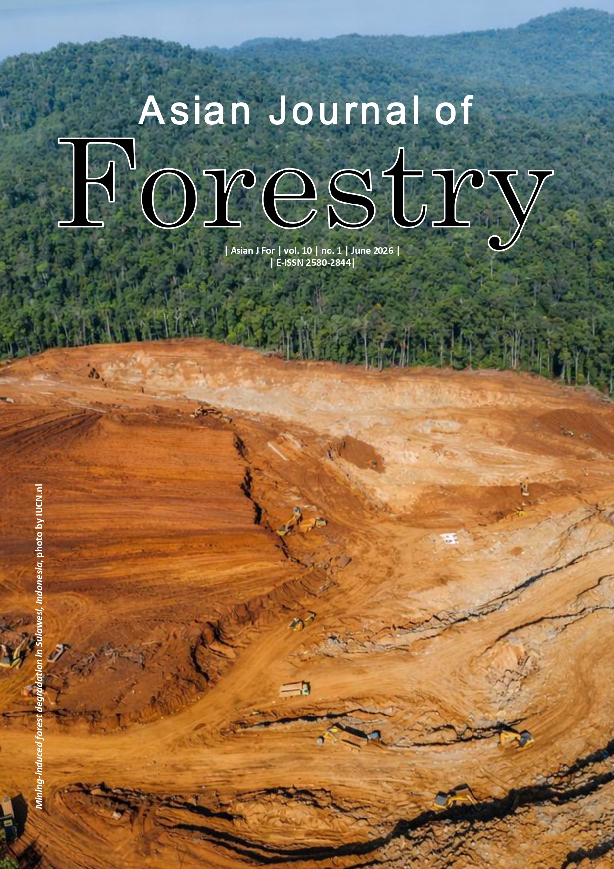
Abstract. Irfaddien R, Kiswanto, Herlambang H, Anwar S, Farahdita WL. 2026. Forest quality decline and restoration priorities in Indonesia’s New Capital Region. Asian J For 10 (1): r100108. https://doi.org/10.13057/asianjfor/r100108. Rapid development in the Capital City of Nusantara (IKN), East Kalimantan, Indonesia, is occurring within a landscape that still contains extensive humid tropical forest. This study quantifies spatiotemporal Land Cover change (2016-2025) and evaluates landscape-scale ecosystem condition using a Land Cover Quality Index (LCQI) derived from Sentinel-2 imagery, complemented by a DPSIR (Driving force–Pressure–State–Impact–Response) synthesis to frame restoration and management priorities. Land cover was mapped into 10 classes using a Random Forest classifier, achieving an overall accuracy of 85.2% (κ=0.82). Total forest cover decreased from 181,656 ha (70.8%) in 2016 to 138,700 ha (54.1%) in 2025 (-43,000 ha), including primary forest loss of 36,500 ha (-3,650 ha yr-1) and a marked increase in degraded forest (256 to 20,600 ha). Shrubland expanded by 32,600 ha, while built-up area increased from 8,400 to 27,200 ha. Consistent with these transitions, LCQI declined from 71.3 to 54.8, falling below the degradation threshold (≤65), a commonly used screening benchmark in environmental quality assessments. Hotspot analysis identified concentrated forest loss along infrastructure corridors in the northern and eastern parts of IKN, as well as near mining and river-valley conversion fronts. Insights from key-informant interviews (n=25) suggest that capital relocation, associated population growth, and investment flows are prominent drivers associated with land-conversion pressures. We do not directly measure biodiversity responses in the field; therefore, biodiversity implications are inferred from established relationships between forest loss/fragmentation and species viability. The driver–pressure linkages framed in the DPSIR framework should be interpreted as a structured synthesis of evidence and stakeholder perspectives rather than experimentally demonstrated causation. Accordingly, results are presented as spatial risk indicators to support restoration prioritization rather than as observed biological outcomes. Spatially explicit priorities include protecting remaining primary-forest blocks, rehabilitating degraded forest and shrubland-transition areas, and institutionalizing periodic LCQI-based monitoring to support the Forest City vision.
Article Details
Issue
Section

This work is licensed under a Creative Commons Attribution-NonCommercial-ShareAlike 4.0 International License.
How to Cite
References
Anwar S, Sardjono MA, Rujehan, Suhardiman A, Kiswanto, Setiawati, Herlambang H. 2025a. Social capital and institutional gaps in forest governance of Indonesia's new capital city. Asian J For 9 (2): 381-389. https://doi.org/10.13057/asianjfor/r090219. DOI: https://doi.org/10.13057/asianjfor/r090219
Anwar S, Sardjono MA, Rujehan, Suhardiman A, Kiswanto, Setiawati, Herlambang H. 2025b. Strengthening social capital in forest area management to support the Forest Cities of the Nusantara Capital City. J Urban Dev Manag 4 (3): 190-203. https://doi.org/10.56578/judm040302. DOI: https://doi.org/10.56578/judm040302
Flick HM, Teras JT, Kartveit BH. 2025. Applying the DPSIR framework to a Nordic Arctic context - opportunities and challenges. J Land Use Sci 20 (1): 197-220. https://doi.org/10.1080/1747423X.2025.2557798. DOI: https://doi.org/10.1080/1747423X.2025.2557798
Ghazoul J, Chazdon R. 2017. Degradation and recovery in changing forest landscapes: A multiscale theory integrating natural and human dimensions. Annu Rev Environ Resour 42 (1): 123-149. https://doi.org/10.1146/annurev-environ-102016-060736. DOI: https://doi.org/10.1146/annurev-environ-102016-060736
Gilani H, Ahmad S, Qazi WA, Abubakar SM, Khalid M. 2020. Monitoring of urban landscape ecology dynamics of Islamabad Capital Territory (ICT), Pakistan, over four decades (1976-2016). Land 9 (4): 123. https://doi.org/10.3390/land9040123. DOI: https://doi.org/10.3390/land9040123
Government of Indonesia. 2022a. Law of the Republic of Indonesia Number 3 of 2022 on National Capital. https://www.ikn.go.id. [Indonesian]
Government of Indonesia. 2022b. Presidential Regulation of the Republic of Indonesia Number 64 of 2022 on Spatial Plan of the National Strategic Area of the Capital City of Nusantara 2022–2042. https://www.ikn.go.id. [Indonesian]
Haddad NM, Brudvig LA, Clobert J et al. 2015. Habitat fragmentation and its lasting impact on Earth's ecosystems. Sci Adv 1 (2): e1500052. https://doi.org/10.1126/sciadv.1500052. DOI: https://doi.org/10.1126/sciadv.1500052
Hadi Y, Yowargana P, Zulkarnain MT, et al. 2022. A national-scale land cover reference dataset from local crowdsourcing initiatives in Indonesia. Sci Data 9 (1): 574. https://doi.org/10.1038/s41597-022-01689-5. DOI: https://doi.org/10.1038/s41597-022-01689-5
Han H, Guo L, Zhang J, Zhang K, Cui N. 2021. Spatiotemporal analysis of the coordination of economic development, resource utilization, and environmental quality in the Beijing-Tianjin-Hebei urban agglomeration. Ecol Indic 127: 107724. https://doi.org/10.1016/j.ecolind.2021.107724. DOI: https://doi.org/10.1016/j.ecolind.2021.107724
Hending D, Randrianarison H, Andriamavosoloarisoa NNM, Ranohatra-Hending C, Holderied M, McCabe G, Cotton S. 2023. Forest fragmentation and its associated edge-effects reduce tree species diversity, size, and structural diversity in Madagascar's transitional forests. Biodivers Conserv 32 (10): 3329-3353. https://doi.org/10.1007/s10531-023-02657-0. DOI: https://doi.org/10.1007/s10531-023-02657-0
Höhl M, Ahimbisibwe V, Stanturf JA, Elsasser P, Kleine M, Bolte A. 2020. Forest landscape restoration-What generates failure and success? Forests 11 (9): 938. https://doi.org/10.3390/f11090938. DOI: https://doi.org/10.3390/f11090938
Laurance WF, Camargo JLC, Fearnside PM, Lovejoy TE, Williamson GB, Mesquita RCG, Meyer CFJ, Bobrowiec PED, Laurance SGW. 2018. An amazonian rainforest and its fragments as a laboratory of global change. Biol Rev 93 (1): 223-247. https://doi.org/10.1111/brv.12343. DOI: https://doi.org/10.1111/brv.12343
Lu C, Shi L, Fu L, Liu S, Li J, Mo Z. 2023. Urban ecological environment quality evaluation and territorial spatial planning response: Application to Changsha, Central China. Intl J Environ Res Public Health 20 (4): 3753. https://doi.org/10.3390/ijerph20043753. DOI: https://doi.org/10.3390/ijerph20043753
Mansourian S, Vallauri D. 2014. Restoring forest landscapes: Important lessons learnt. Environ Manag 53: 241-251. https://doi.org/10.1007/s00267-013-0213-7. DOI: https://doi.org/10.1007/s00267-013-0213-7
Peraturan Presiden (Perpres) No. 64 Tahun 2022. 2022. Peraturan tentang Rencana Tata Ruang Kawasan Strategis Nasional Ibu Kota Nusantara (IKN) Tahun 2022-2042. [Indonesian]
Quevedo JMD, Lukman KM, Ulumuddin YI, Uchiyama Y, Kohsaka R. 2023. Applying the DPSIR framework to qualitatively assess the globally important mangrove ecosystems of Indonesia: A review towards evidence-based policymaking approaches. Mar Policy 147: 105354. https://doi.org/10.1016/j.marpol.2022.105354. DOI: https://doi.org/10.1016/j.marpol.2022.105354
Rahmawaty, Rauf A, Harahap MM, Kurniwan H. 2022. Land cover change impact analysis: An integration of remote sensing, GIS and DPSIR framework to deal with degraded land in Lepan Watershed, North Sumatra, Indonesia. Biodiversitas 23: 3000-3011. https://doi.org/10.13057/biodiv/d230627. DOI: https://doi.org/10.13057/biodiv/d230627
Reiche J, Lucas R, Mitchell AL, Verbesselt J, Hoekman DH, Haarpaintner J, Kellndorfer JM, Rosenqvist A, Lehmann EA, Woodcock CE, Seifert FM, Herold M. 2016. Combining satellite data for better tropical forest monitoring. Nat Clim Chang 6: 120-122. https://doi.org/10.1038/nclimate2919. DOI: https://doi.org/10.1038/nclimate2919
Roy S, Bose A, Majumder S, Chowdhury IR, Abdo HG, Almohamad H, Dughairi AAA. 2022. Evaluating Urban Environment Quality (UEQ) for Class-I Indian city: An integrated RS-GIS based exploratory spatial analysis. Geocarto Int 38 (1): 2153932. https://doi.org/10.1080/10106049.2022.2153932. DOI: https://doi.org/10.1080/10106049.2022.2153932
Virtriana R, Ihsan KTN, Anggraini TS, Harto AB, Riqqi A, Deliar A. 2025. Predicting suitable built-up areas in Indonesia's new capital: Integrating ecosystems, access, and socioeconomics. Sustain Futures 10: 101342. https://doi.org/10.1016/j.sftr.2025.101342. DOI: https://doi.org/10.1016/j.sftr.2025.101342
Wang R, Sun Y, Zong J, Wang Y, Cao X, Wang Y, Cheng X, Zhang W. 2024. Remote sensing application in ecological restoration monitoring: A systematic review. Remote Sens 16 (12): 2204. https://doi.org/10.3390/rs16122204. DOI: https://doi.org/10.3390/rs16122204
Wang SW, Gebru BM, Lamchin M, Kayastha RB, Lee WK. 2020. Land use and land cover change detection and prediction in the Kathmandu District of Nepal using remote sensing and GIS. Sustainability 12 (9): 3925. https://doi.org/10.3390/su12093925. DOI: https://doi.org/10.3390/su12093925
Yao S, Li Y, Quan X, Xu J. 2024. Applying the driver-pressure-state-impact-response model to ecological restoration: A case study of comprehensive zoning and benefit assessment in Zhejiang Province, China. Glob Ecol Conserv 55: e03222. https://doi.org/10.1016/j.gecco.2024.e03222. DOI: https://doi.org/10.1016/j.gecco.2024.e03222
Yousafzai S, Saeed R, Rahman G, et al. 2022. Spatio-temporal assessment of land use dynamics and urbanization: Linking with environmental aspects and DPSIR framework approach. Environ Sci Pollut Res 29: 81337-81350. https://doi.org/10.1007/s11356-022-21393-6. DOI: https://doi.org/10.1007/s11356-022-21393-6